
‘Most catastrophic storm ever seen before’
Irma continues to batter communities, leaving behind devastation, destruction
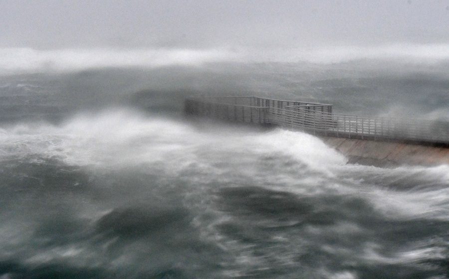
TOO MUCH WATER. Hurricane Irma batters the Floridian shore as it makes landfall. Even though the center may have passed some areas, there is still much danger to come. “The most important thing to understand is that the Gulf water will surge in and rise quickly WELL AFTER the strongest winds go by. You might think the storm is ending, but the deadliest part of the storm is still to come,” posted Bryan Norcross, senior hurricane specialist on The Weather Channel, on Facebook.
After wreaking devastation in the Caribbean and forcing one of the largest evacuations in American history, Hurricane Irma roared ashore on Cudjoe Key, FL at 9:10 a.m. on Sun., Sept. 10.
The eye of the Category 4 storm wrecked havoc on the lower Florida Keys, with maximum sustained winds of 130 mph.
After reaching Florida’s southwest coast, it made a second landfall in Marco Island, FL at 3:35 p.m. as a Category 3 storm before further weakening to a Category 2 as it hit Naples at 5:00 p.m.
However, with maximum wind speeds of 110 mph, it is “expected to remain a powerful hurricane while it moves near or along the west coast of Florida,” according to the National Hurricane Center (NHC).
In Tampa and St. Petersburg, both considered ill-equipped to confront a storm of this size by experts, 6:00 p.m. curfews have been declared.
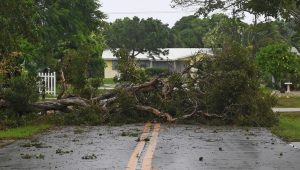
Cities on the eastern Floridian coast, despite having been spared from Irma’s direct path, are being inundated by surging waters. Rivers and lakes overflowed while winds tore up signs, downed power lines, and ripped trees from the ground.
“That’s going to continue to get worse over the next few hours. It’s going to be a very long evening,” said Chris Fisher, a meteorologist with the National Weather Service (NWS), according to The New York Times.
In downtown Miami, a crane collapsed due to harsh winds.
Even more dangerous than the winds are the storm surges that continue to threaten Florida’s coastal cities.
“There is a serious threat of significant storm surge flooding along the entire west coast of Florida. And this has increased to 15 feet of impact above ground level in southwest Florida,” said Florida Governor Rick Scott in a news conference.
The Florida Keys could get ten to 20 inches of rain, and the peninsula could receive eight to 15 inches.
“A very dangerous day is unfolding in the Florida Keys and much of West Florida. It…could inundate the entire island. That’s why everyone in the Keys was urged…to evacuate,” said Michael Brennan, senior hurricane specialist at the NHC.
Irma’s Timeline
- Tues., Sept. 5: At night, Irma passed directly over Barbuda and St. Martin, the strongest hurricane recorded in the region. The weather station in Barbuda clocked a wind gust of 155 mph before it went offline.
- Wed., Sept. 6: The storm passed directly over Anguilla and St. Martin, causing severe damage. Early in the afternoon, the eye moved over Virgin Gorda in the British Virgin Islands, with the eyewall raking St. Thomas in the U.S. Virgin Islands.
- Thurs., Sept. 7: The eye of the storm passed very close to the Turks and Caicos, producing potentially catastrophic Category 4 winds and raising concerns for storm surges. Later in the day, the eye passed north of Puerto Rico, with a wind gust of 111 mph clocked in Culebra. More than 900,000 people were reported to be without power.
- Fri., Sept. 8: Before making landfall along Cuba’s north-central coast, Irma passed north of Haiti and between Cuba’s northeast coast and the central Bahamas.
Tornado warnings are in place across the state as thousands of Florida residents hunker down in homes and shelters.
Floridian Matthew Spuler captured video of waves crashing over a seawall from his building in downtown Miami.
“There is no seawall whatsoever. It’s amazing. It’s under water,” Spuler said on the video.
President Donald Trump has declared a major disaster in Florida, ordering federal funds to supplement state, tribal, and local recovery efforts.
Assistance includes “grants for temporary housing and home repairs, low-cost loans to cover uninsured property losses, and other programs to help individuals and business owners recover from the effects of the disaster,” said the White House in a statement.
At least 70 additional shelters were opened across Florida on Saturday to deal with the flood of people seeking safety. According to Scott, at least 50,000 people are staying in 260 shelters across the state.
Currently, the death toll is at 24, with four reported in Florida. However, this is expected to rise as Irma continues on.
More than 2.3 million Floridians are currently without power, a number expected to continue rising as Irma batters the state. Residents are relying on the remaining power on their cell phones to keep in touch with the world.
“People ask what they can do for us. Pray for us. We need volunteers, nurses. I hope everybody will pray for us. We can pray, that’s the biggest thing we can do,” Scott said in a conference.
For updates on Irma’s progress, click here.
Sources:
- www.huffingtonpost.com/entry/hurricane-irma-records-broken_us_59b48a93e4b0dfaafcf84e6a
- www.theguardian.com/world/live/2017/sep/10/hurricane-irma-millions-brace-for-impact-as-superstorm-reaches-florida-live
- www.telegraph.co.uk/news/2017/09/10/hurricane-irma-florida-keys-latest-news/
- www.accuweather.com/en/weather-news/hurricane-irma-batters-florida-with-catastrophic-storm-surge-wind-and-rain/70002657
- www.nbcnews.com/storyline/hurricane-irma/hurricane-irma-begins-batter-florida-keys-gov-scott-warns-leave-n800006
- www.nbcnews.com/storyline/hurricane-irma/hurricane-irma-how-help-storm-victims-n800101
- www.nytimes.com/2017/09/10/us/hurricane-irma-florida.html?mcubz=1
- www.cnn.com/2017/09/10/us/hurricane-irma-florida-impact/index.html
- www.cnn.com/2017/09/09/us/hurricane-irma-florida-latest/index.html
- www.youtube.com/watch?v=NhNxeEAt41A
- www.washingtonpost.com/news/capital-weather-gang/wp/2017/09/10/after-slamming-keys-irma-to-batter-florida-peninsula-catastrophic-storm-surge-feared/?utm_term=.355d5d046d45
- www.washingtonpost.com/national/2017/live-updates/weather/hurricane-irma-a-monster-storms-devastating-path/?hpid=hp_hp-top-table-main_liveblog-950a%3Aprime-time%2Fpromo&utm_term=.5aabd8c38ea4
- www.washingtonpost.com/news/post-nation/wp/2017/09/10/hurricane-irma-makes-landfall-in-florida-keys-targets-gulf-coast/?utm_term=.7a0b882145ef
Your donation will support the student journalists of Sycamore High School. Your contribution will allow us to purchase equipment and cover our annual website hosting costs.